
Finding your way around the Paris transport network can be dizzying. Between the intersecting metro lines, the RER trains crossing the region, and the trams on the outskirts, even regular users sometimes hesitate in front of an overloaded official map. A simplified map changes the game: it removes the visual noise to keep only the useful connections and the main traffic routes.
Metro-RER-Tramway Connections: What a Simplified Map Finally Makes Clear
The official Île-de-France network map overlays hundreds of stations, precise geographical routes, and fare information. The result is comprehensive but difficult to use when you simply want to switch from the metro to the RER without going in the wrong direction.
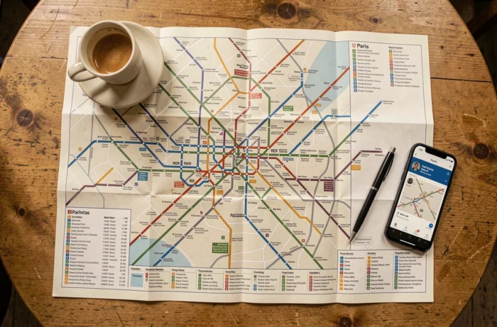
A simplified map adopts a different logic. It groups transport modes by color and axis, removes little-used intermediate stations, and highlights connection hubs. You can see at a glance where the RER A intersects with line 1, or at which station tram T3 meets the metro.
This type of representation particularly helps occasional travelers and tourists. Instead of memorizing the exact route of each line, it’s enough to identify the starting point, the destination, and the necessary transfers. A simplified map of Paris transport allows you to visualize these connections between buses, metro, RER, and tram on a single clean layout.

End of Cardboard Tickets: Adapting Your Map Reading to New Transport Titles
You may still have some cardboard tickets at the bottom of your wallet. Their gradual disappearance, initiated by Île-de-France Mobilités starting in November 2025, changes the way we plan a journey on a map.
Two categories of tickets replace the old t+ ticket:
- The Metro-Train-RER Ticket covers journeys combining metro and RER within Paris, with possible transfers between these two modes on the same ticket.
- The Bus-Tram Ticket is dedicated to bus and tram journeys. A transfer to the metro requires a separate ticket, unless you have a pass.
- Digital supports (Navigo Easy, Navigo Liberté+, phone) become the standard for loading these tickets and validating contactless.
On a simplified map, this distinction is concretely reflected. The metro and RER lines form one fare group. The bus and tram lines form another. Identifying the mode of transport on the map determines the ticket to use.
Navigo Liberté+ for Occasional Journeys
For travelers who do not use public transport every day, the Navigo Liberté+ contract charges for each journey based on actual use, with daily and weekly caps. It avoids the need to buy individual tickets and works across the entire network. The simplified map remains useful for anticipating the number of validations needed based on planned transfers.
Station Accessibility: The Blind Spot of Simplified Maps
A map that summarizes connections says nothing about the actual accessibility of a station. This is an angle that streamlined maps systematically overlook, and it poses a real problem for people with reduced mobility.
Historic metro lines are not uniformly accessible. The lack of elevators in most old stations makes certain routes impractical for wheelchair users or those with strollers, even if the transfer exists on the map.
Line 14, automated and recently designed, is an exception with full accessibility. Future lines of the Grand Paris Express are designed according to the same principle. On a simplified map, nothing visually distinguishes these accessible lines from others.
Check Accessibility Before Planning a Journey
Before following a route identified on a simplified map, check accessibility station by station via the Bonjour RATP app or the Île-de-France Mobilités website. These tools indicate the presence of elevators, escalators, and tactile paving. The simplified map provides direction, while the app provides feasibility.
Paris Buses on a Simplified Map: Identifying Key Lines
The Paris bus network has a large number of lines, making it particularly difficult to map without saturating the plan. A simplified map makes a choice: it retains only the key lines, those that cross Paris from one end to the other or that ensure major connections with the metro and RER.
Looking to cross Paris from east to west without going underground? The bus lines that use the major boulevards are clearly visible on a clean map. The bus remains the only mode that allows you to see the city while moving, an advantage that neither the metro nor the RER can offer.
The Tzen lines, currently being developed in the outer suburbs, add a new type of transport that is halfway between a classic bus and a tram. They have dedicated lanes and equipped stations.
Tramway on the Outskirts: The Logical Complement to the Metro
The tram lines form a belt around Paris and serve the neighboring municipalities. On a simplified map, they often appear at the edges, with their transfer points to the metro or RER clearly identified.
The T3 tramway connects the gates of Paris and serves as an alternative to the metro for peripheral journeys.
A simplified map of Paris transport does not replace a route planner. It offers an overview that detailed applications paradoxically make harder to obtain. Keeping a clean map handy, alongside a digital tool for schedules and accessibility, remains the most reliable combination for moving stress-free within the Île-de-France network.